|
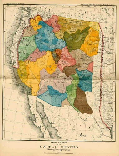
A veteran of the Civil War, John Wesley Powell, began the exploration of the arid west in 1869 to analyze its unique characteristics. At the time the Western United States was comprised of a group of territories in a landscape much of which was devoid of the lush vegetation characteristic of the Eastern part of the North American continent. This land—the Great American Desert—created developmental challenges for the US Government. Unlike the East and Mid-West water was scarce and an intricate system of water diversions and distribution canals was necessary to develop these territories into productive regions. Yet in 1890 a report from Powell to the Senate Select Committee on Irrigation and Reclamation of Arid Lands fell on deaf ears. Based upon Powell’s accumulation of data and findings from earlier western lands explorations he recommended the development of political jurisdictions based on hydrologic divides or watersheds. He was ignored, and states were created along arbitrary boundaries devoid of any natural physical land characteristic. It would take nearly 50 years before Powell’s recommendations would be instituted, but not from the Federal Government.  Powell’s map on the left depicted with jurisdictions bounded by natural hydrologic features. Water drainages would have political jurisdictions distinctly divided by natural water courses and their corresponding water sources. Colorado, a headwaters state which sends water to all the arid regions of the west, was the first to develop legislation authorizing the creation of political subdivisions designed to have jurisdiction over watershed regions. Powell’s recommendation would take root within a state under the legislative authority of the Water Conservancy Act. The Upper Arkansas Water Conservancy District is one of these entities.
The Water Conservancy Act was adopted by Colorado in 1935. It charges these water districts with the responsibility to do “Works” as defined in the statute. These Works are the development of water and power resources both physical and intangible. Some of the physical structures are reservoirs and water diversions to supply water for irrigation, municipal, industrial and other uses within its jurisdiction. Intangible assets may be accumulated data on weather and stream flows, acquisition of decrees for water rights, or the creation of augmentation plans that cover large portions of a watershed. Other political subdivisions, such as counties do not have the jurisdictional authority to conduct water activities, and because their boundaries are arbitrary and do not necessarily follow hydrologic divides, which are essential to the accomplishment of major water works. Since revenues obtained by political subdivisions must be utilized for the benefit of the citizens within that division, these revenues cannot be used to benefit a part of a watershed outside the political subdivision. Likewise, the authority to direct the use of these revenues outside a political subdivision is lacking. For example, funds spent on a project inside a county generated from a levy upon the citizens of that county cannot be utilized to benefit the watershed outside of that county. Powell recognized this reality although on a larger scale. Water Conservancy Districts undertake watershed-wide projects authorized through the Water Conservancy Act. One of the present conundrums being discussed by some entities is how to undertake basin-wide projects—such as forest health and stream management projects. The clear answer lies in the Water Conservancy Act. It is through Water Conservancy Districts with basin-wide jurisdiction that these projects can be undertaken. Some recent articles have been written about large scale projects of the Upper Arkansas Water Conservancy District that create benefits for large portions of the Upper Arkansas watershed. The District has the jurisdictional authority to utilize revenue from various sources including its own revenue sources and match the revenue source commensurate with a localized benefit. On a smaller scale the District has undertaken integrated water management projects with municipalities on tributary drainages such as the South Arkansas River. On a larger scale the District’s Umbrella Augmentation Plan crosses several counties, all within the same watershed. The District can combine cost share funds from several political subdivisions with state and federal grants. Other entities lack these abilities either because they lack specific legal authority or are unable to expend funds for benefits outside their jurisdictions. As the population of the Arkansas Basin increases the challenges of providing adequate clean water supplies will increase. It is comforting to know and understand that these challenges can be met by good planning and actions of our Water Conservancy Districts. In the Upper Arkansas watershed that entity is the Upper Arkansas Water Conservancy District. You can learn more about our projects at www.uawcd.com or by contacting the District and finding out about our Water Talks education program.
0 Comments
Leave a Reply. |
ABOUTLocal water news by the Upper Arkansas Water Conservancy District Archives
August 2023
Categories |
CONNECT |
|
UAWCD Technology Accessibility Statement
UAWCD is committed to providing equitable access to our services to all Coloradans.
Our ongoing accessibility effort works towards being in line with the Web Content Accessibility Guidelines (WCAG) version 2.1, level AA criteria. These guidelines not only help make technology accessible to users with sensory, cognitive and mobility disabilities, but ultimately to all users, regardless of ability.
Our efforts are just part of a meaningful change in making all State of Colorado and local government services inclusive and accessible. We welcome comments on how to improve our technology’s accessibility for users with disabilities and for requests for accommodations to any UAWCD services.
Requests for accommodations and feedback
We welcome your requests for accommodations and feedback about the accessibility of UAWCD’s online services. Please let us know if you encounter accessibility barriers. UAWCD is committed to responding as quickly as possible.
E-mail: [email protected]
Mail: P.O. Box 1090, Salida, CO 81201
Phone: 719-539-5425 (Written requests are preferred. If you are unable to submit your request in writing, you are welcome to contact us by telephone at this number.)

 RSS Feed